


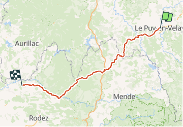
SAINT JACQUES DE COMPOSTELLE: LE PUY EN VELAY - CONQUES

djeepee74
Gebruiker

Lengte
218 km

Max. hoogte
1368 m

Positief hoogteverschil
5274 m
Km-Effort
289 km

Min. hoogte
290 m

Negatief hoogteverschil
5596 m
Boucle
Neen
Datum van aanmaak :
2023-06-09 15:47:45.659
Laatste wijziging :
2023-06-09 16:55:09.593
66h00
Moeilijkheid : Moeilijk

Gratisgps-wandelapplicatie
 SityTrail
IGN / Geografische instituten
SityTrail Plus
De wereld gaat voor u open
Over ons
Tocht Stappen van 218 km beschikbaar op Auvergne-Rhône-Alpes, Haute-Loire, Le Puy-en-Velay. Deze tocht wordt voorgesteld door djeepee74.
Beschrijving
live du 28 mai au 06 juin 2023...
soit 10 jours de marche... et 66 heures en déplacement.
Plaatsbepaling
Land:
France
Regio :
Auvergne-Rhône-Alpes
Departement/Provincie :
Haute-Loire
Gemeente :
Le Puy-en-Velay
Locatie:
Unknown
Vertrek:(Dec)
Vertrek:(UTM)
569956 ; 4988114 (31T) N.
Opmerkingen